GeoRSS
The GeoRSS integrationIntegrations connect and integrate Home Assistant with your devices, services, and more. [Learn more] retrieves events from a GeoRSS feed and shows information of those events filtered by distance to Home Assistant’s location and grouped by category.
This integrationIntegrations connect and integrate Home Assistant with your devices, services, and more. [Learn more] is particularly useful if events occur unexpectedly in the vicinity of the home while the GeoRSS feed also contains many events representing distant unrelated entries. Typical examples are bush fires alerts or earthquakes.
The reference point for comparing the distance is by default defined by latitude and longitude in the basic configuration.
Only entries of the feed are considered that define a location as point or polygon in georss.org format or as WGS84 latitude/longitude.
The data is updated every 5 minutes.
Configuration
To enable the GeoRSS events sensor, add the following lines to your configuration.yamlThe configuration.yaml file is the main configuration file for Home Assistant. It lists the integrations to be loaded and their specific configurations. In some cases, the configuration needs to be edited manually directly in the configuration.yaml file. Most integrations can be configured in the UI. [Learn more] file.
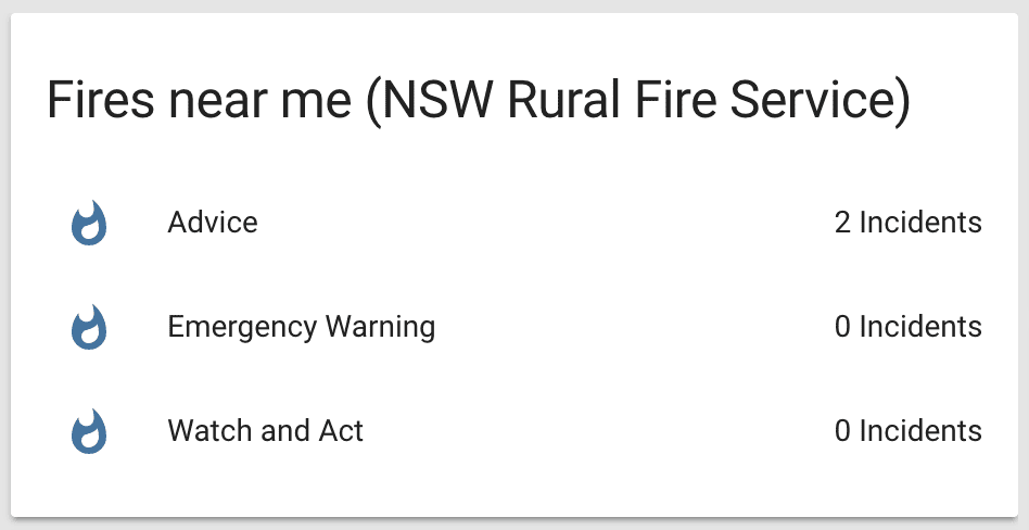
This is an example configuration showing bush fire incidents from the NSW Rural Fire Service.
After changing the configuration.yamlThe configuration.yaml file is the main configuration file for Home Assistant. It lists the integrations to be loaded and their specific configurations. In some cases, the configuration needs to be edited manually directly in the configuration.yaml file. Most integrations can be configured in the UI. [Learn more] file, restart Home Assistant to apply the changes. The integration is now shown on the integrations page under Settings > Devices & services. Its entities are listed on the integration card itself and on the Entities tab.
# Example configuration.yaml entry
sensor:
  - platform: geo_rss_events
    name: NSW Fire Service
    url: https://www.rfs.nsw.gov.au/feeds/majorIncidents.xml
    unit_of_measurement: "Incidents"
    categories:
      - 'Emergency Warning'
      - 'Watch and Act'
      - 'Advice'
Configuration Variables
Latitude of the coordinates around which events are considered.
Latitude defined in your configuration.yaml
Longitude of the coordinates around which events are considered.
Longitude defined in your configuration.yaml
The distance in kilometers around the Home Assistant’s coordinates in which events are considered.
List of event category names found in the GeoRSS feed. A separate sensor is created for each category defined.
Default is to join events from all categories into an ‘Any’ category.
Example Feeds
Bush Fire Alerts
sensor:
  - platform: geo_rss_events
    name: Qld Fire and Emergency Services
    url: https://www.qfes.qld.gov.au/data/alerts/bushfireAlert.xml
    unit_of_measurement: "Alerts"
  - platform: geo_rss_events
    name: TasALERT
    url: https://alert.tas.gov.au/data/incidents-and-alerts.xml
    unit_of_measurement: "Alerts"
  - platform: geo_rss_events
    name: WA Department of Fire and Emergency Services
    url: https://www.emergency.wa.gov.au/data/incident_FCAD.rss
  - platform: geo_rss_events
    name: ACT Emergency Services Agency
    url: https://www.esa.act.gov.au/feeds/currentincidents.xml
Earthquake Alerts
sensor:
  - platform: geo_rss_events
    name: USGS All Earthquakes
    url: https://earthquake.usgs.gov/earthquakes/feed/v1.0/summary/all_day.atom
    categories:
      - 'Past Hour'
      - 'Past Day'
  - platform: geo_rss_events
    name: BGS Worldwide Earthquakes
    url: http://earthquakes.bgs.ac.uk/feeds/WorldSeismology.xml
    categories:
      - 'EQMH'
  - platform: geo_rss_events
    name: Recent significant earthquake reports (Canada)
    url: https://www.earthquakescanada.nrcan.gc.ca/cache/earthquakes/canada-en.atom
    categories:
      - 'Earthquake Report'